Home Status

South Africa: the Port of Durban

Four corridors: North, Egypt · East, Kenya (LAPSSET) · West, Nigeria · South, South Africa · all four

The south point of our four corridors. South Africa's busiest container port, read from free radar and optical satellite passes, with this week's public status beside it.
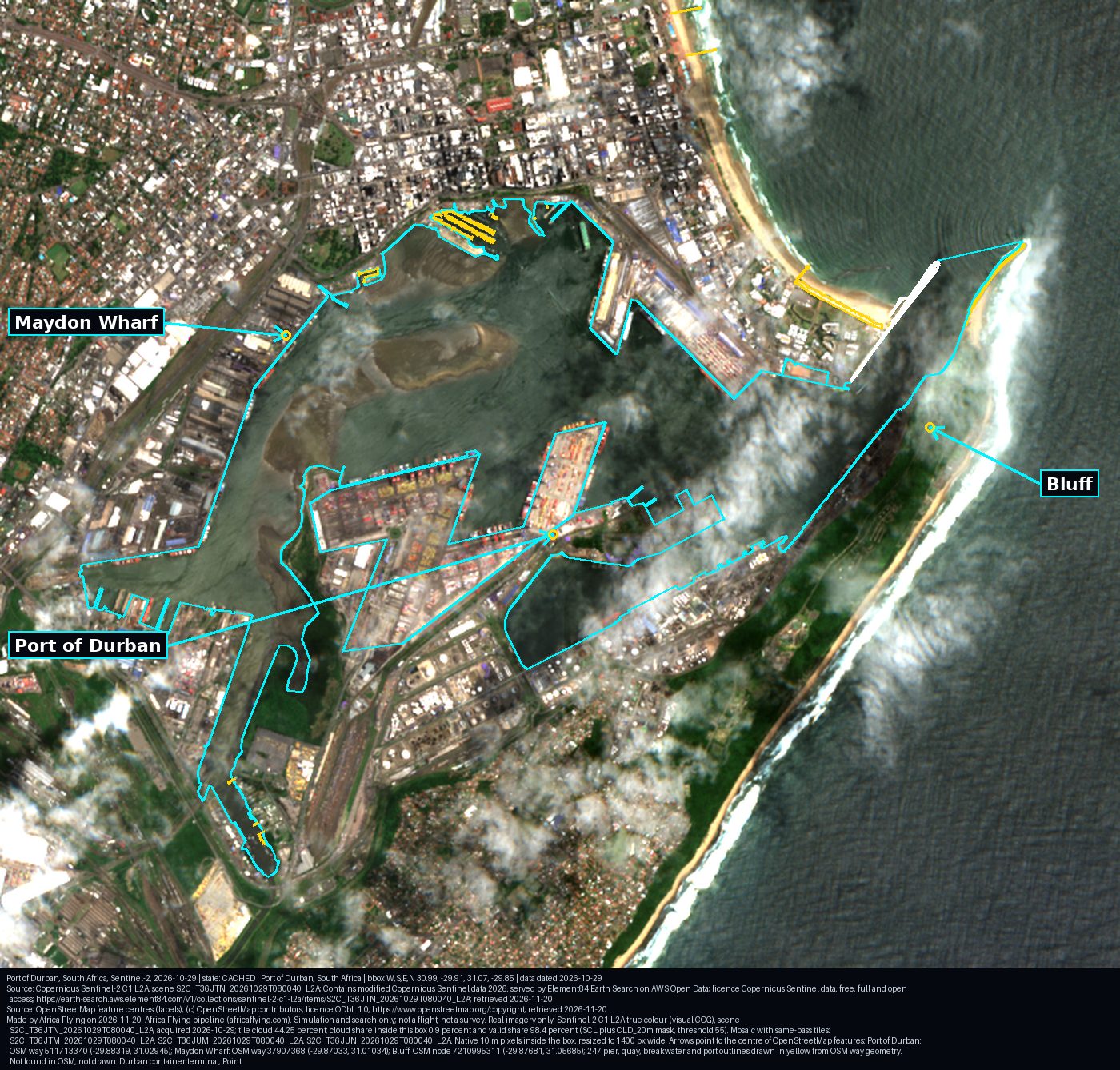
The Port of Durban, South Africa. Sentinel-2 true colour, 29 Oct 2026, up to 4.2 percent cloud over the box (mostly clear). Arrows from OpenStreetMap point to Port of Durban, Maydon Wharf, Bluff.
The Port of Durban, 29 Oct 2026. Quays and piers outlined from OpenStreetMap.Credit: Copernicus Sentinel-2 (2026-10-29), processed by Africa Flying. Labels (c) OSM, ODbL. Licence: Copernicus open data. Source. Provenance.

What the satellites saw over Durban, last 90 days

ReadingValue
Radar passes (Sentinel-1, sees through cloud) usable over the box19 of 19
Optical scenes (Sentinel-2) with a usable view after the pixel cloud mask56 of 88, on 14 days
Median whole-tile cloud65.8 percent
Window22 Aug 2026 to 20 Nov 2026

Radar and optical counts are kept apart and never added. Usable means at least 15 percent of the box is clear after the cloud mask (Sentinel-2 scene classes plus the free cloud-probability band) or, for radar, has valid pixels. Sources: Element84 Earth Search (Copernicus Sentinel-2 Collection 1) and Microsoft Planetary Computer (Sentinel-1 RTC, CC BY 4.0), read 20 Nov 2026.

What is happening at the port

These are public statements with their dates. They are not Africa Flying measurements.

ComponentPublic statusSource
Durban Gateway Terminal (Pier 2)Operated under a 25-year arrangement from 1 January 2026Parliament reply NW5320
Backlog measures, 18 Nov 2026Berth 102 set aside for geared vessels; more vessels diverted to Ngqura; trains made available to move import containers to GautengTransnet media statement, 18 Nov 2026
Pier 1 cranesFinal refurbished ship-to-shore crane scheduled for commissioning on 20 Nov 2026 and handover to operations on 21 Nov 2026, giving six cranes (as stated 18 Nov)Transnet media statement, 18 Nov 2026
Ngqura container terminalPrivate participation in project preparation (23 Oct 2026)Parliament reply NW5449
Richards Bay dry bulk terminalIn procurement; request for quotations closed 30 Oct 2026Parliament reply NW5449
Freight rail accessThird-party access allocated on six corridors in 2026, including the coal line to Richards Bay and the Sishen-Saldanha iron-ore lineRailway Gazette, Apr 2026
Solar, Bid Window 73,940 MW across 18 solar PV projects; the first reached financial close in April 2026Minister reply NW5144 and IPP Office lists

Ngqura and Richards Bay

Two more port boxes, traced from OpenStreetMap on 21 Nov 2026 (ODbL). They are not in the daily pass list. Each box is the named terminal, plus piers within 500 m at Ngqura, padded outward to the next 0.01 degree. These pictures are not a measurement of the public status table above.
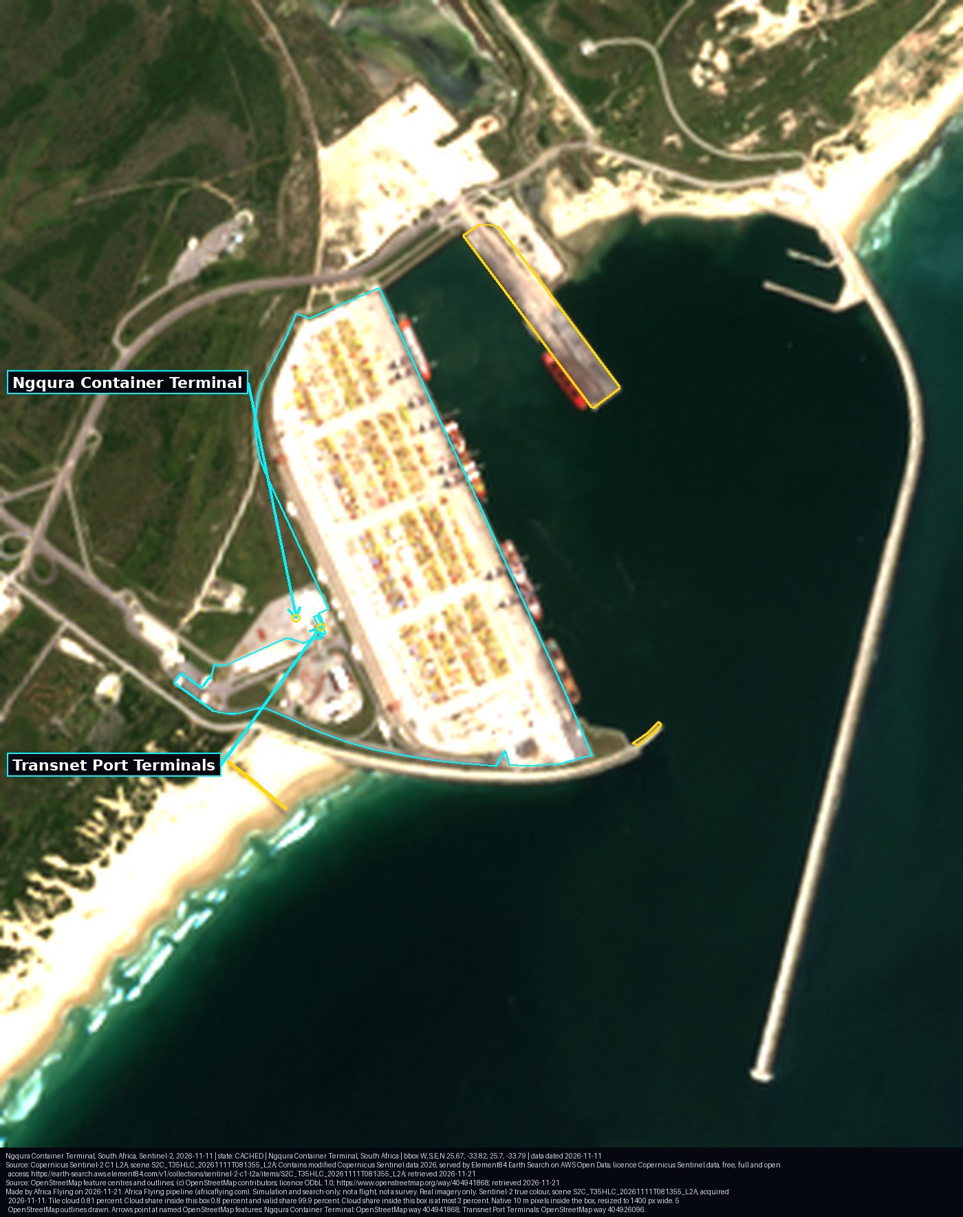
Ngqura Container Terminal, South Africa. Sentinel-2 true colour, 11 Nov 2026, 0.8 percent cloud over the box. Arrows from OpenStreetMap point to Ngqura Container Terminal and Transnet Port Terminals.
Ngqura Container Terminal, 11 Nov 2026. The terminal and nearby piers outlined from OpenStreetMap.Credit: Copernicus Sentinel-2 (2026-11-11), processed by Africa Flying. Labels (c) OSM, ODbL. Licence: Copernicus open data. Source. OpenStreetMap way 404941868, retrieved 21 Nov 2026. Provenance.
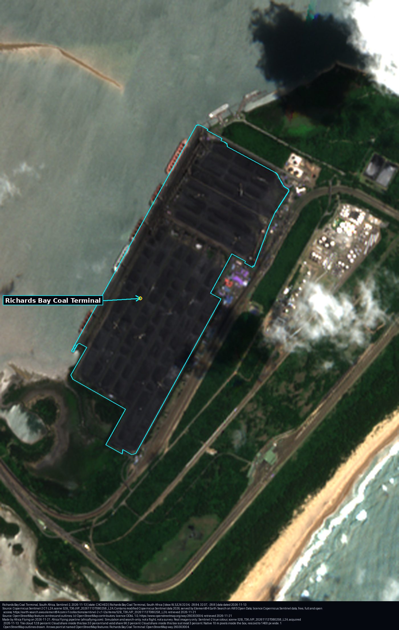
Richards Bay Coal Terminal, South Africa. Sentinel-2 true colour, 13 Nov 2026, 3.0 percent cloud over the box. An arrow from OpenStreetMap points to Richards Bay Coal Terminal.
Richards Bay Coal Terminal, 13 Nov 2026. The terminal outlined from OpenStreetMap.Credit: Copernicus Sentinel-2 (2026-11-13), processed by Africa Flying. Labels (c) OSM, ODbL. Licence: Copernicus open data. Source. OpenStreetMap way 260303004, retrieved 21 Nov 2026. Provenance.

Durban ship-at-anchor count: not assessed. Both boxes are clean: each is a named port polygon with its OpenStreetMap URL, the ODbL licence, and the retrieved date, and neither overlaps the Port of Durban. OpenStreetMap has no anchorage in the Durban roadstead. The marked area east of the port is a no-anchoring area, not an anchorage, so no radar count was made.

Fire hotspots across South Africa this week
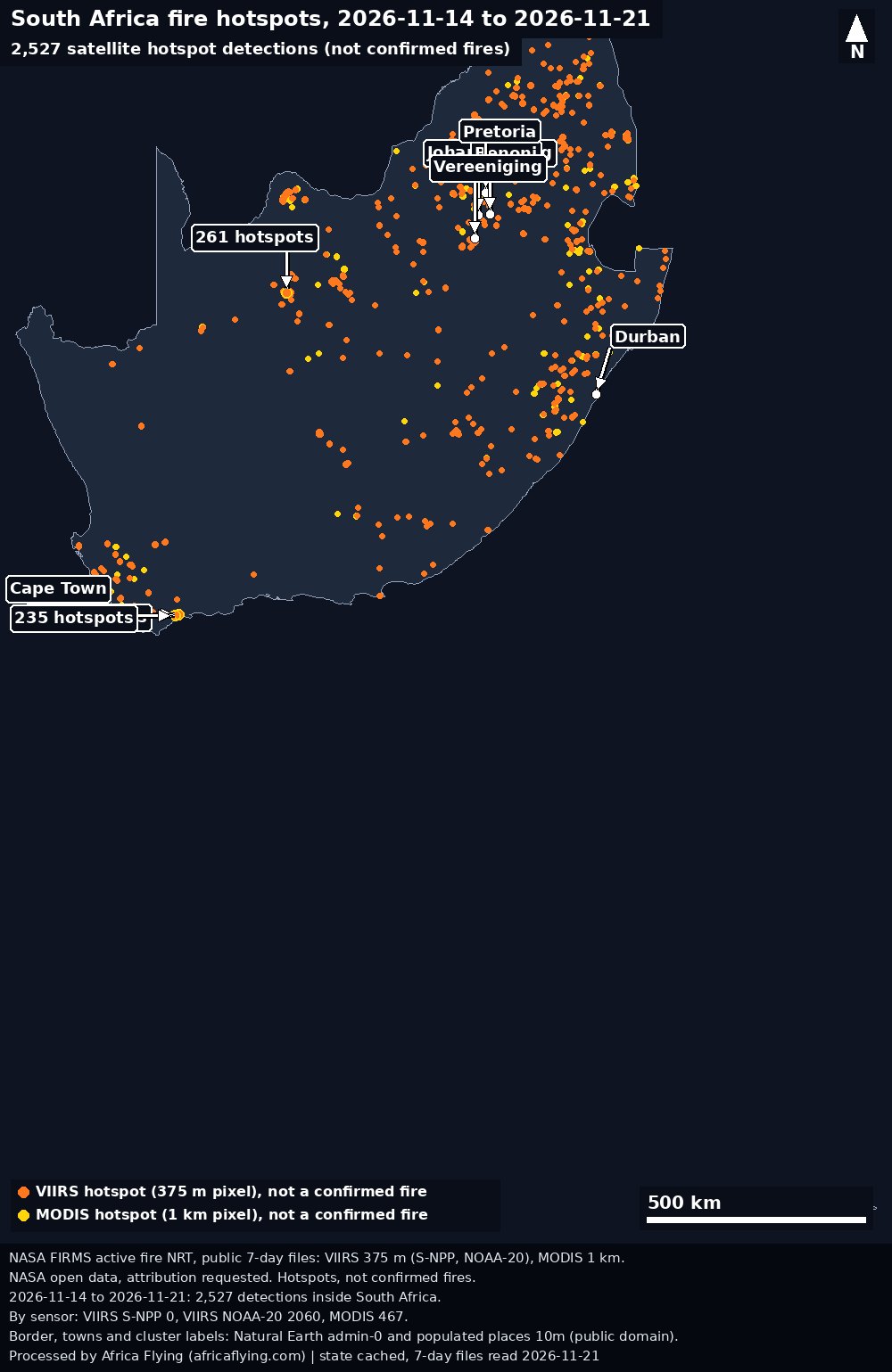
Map of South Africa with NASA FIRMS hotspot detections from 13 Nov 2026 to 20 Nov 2026. 3,129 detections. Each dot is a detection, not a confirmed fire.
South Africa hotspot detections, 13 Nov 2026 to 20 Nov 2026: 3,129. Each dot is a detection, not a confirmed fire.Credit: NASA FIRMS, processed by Africa Flying. Outline: Natural Earth. Licence: NASA open data. Source. Provenance.

Earlier weeks stay on Fire across Africa.

More for South Africa

South Africa airfields and ports (open list) · South Africa readings · the four corridors · the LAPSSET method.