Home Status

Africa, seen from space

Free satellite data, processed by our pipeline, labelled so anyone can read it. R&D preview, not flight operations.

data unavailable Last updated data unavailable Newest imagery data unavailable Last synced data unavailable
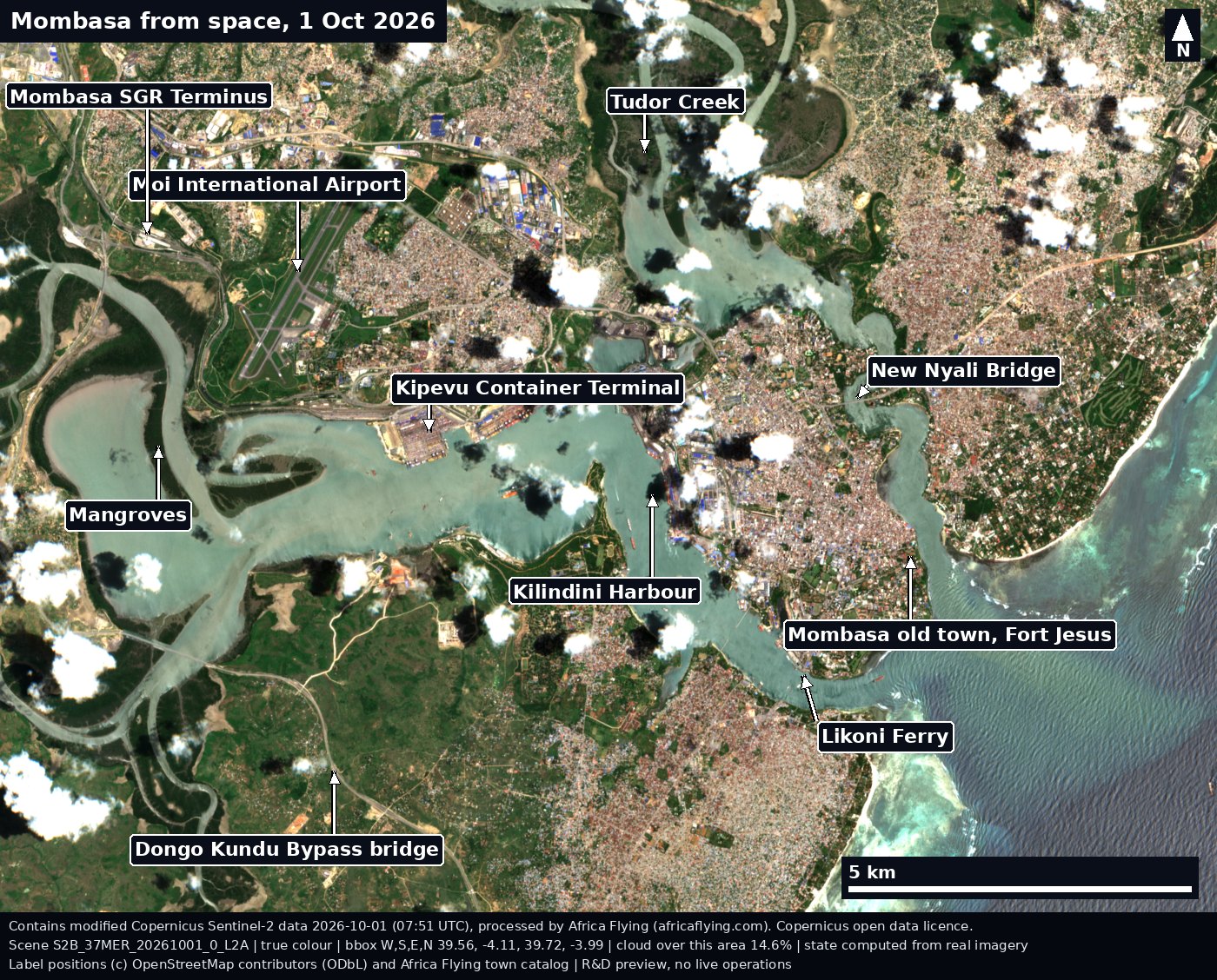
Sentinel-2 true-colour view of Mombasa, Kenya, on 1 October 2026, with labelled arrows to Kilindini Harbour, Tudor Creek, the old town and Fort Jesus, Likoni Ferry, Moi International Airport, the SGR terminus, the Kipevu container terminal, the Dongo Kundu bypass bridge, mangroves and the New Nyali Bridge. Some small clouds.
Mombasa, 1 Oct 2026. Tap for full resolution.Credit: Copernicus Sentinel-2 L2A (2026-10-01), processed by Africa Flying. Labels (c) OpenStreetMap contributors, ODbL. Licence: Copernicus open data. Scene S2B_37MER_20261001_0_L2A. Data date 2026-10-01. Cached at 19 Oct 2026 (saved image file). Provenance.

Latest scenes

Recent Sentinel-2 passes, every one with its date and scene ID.
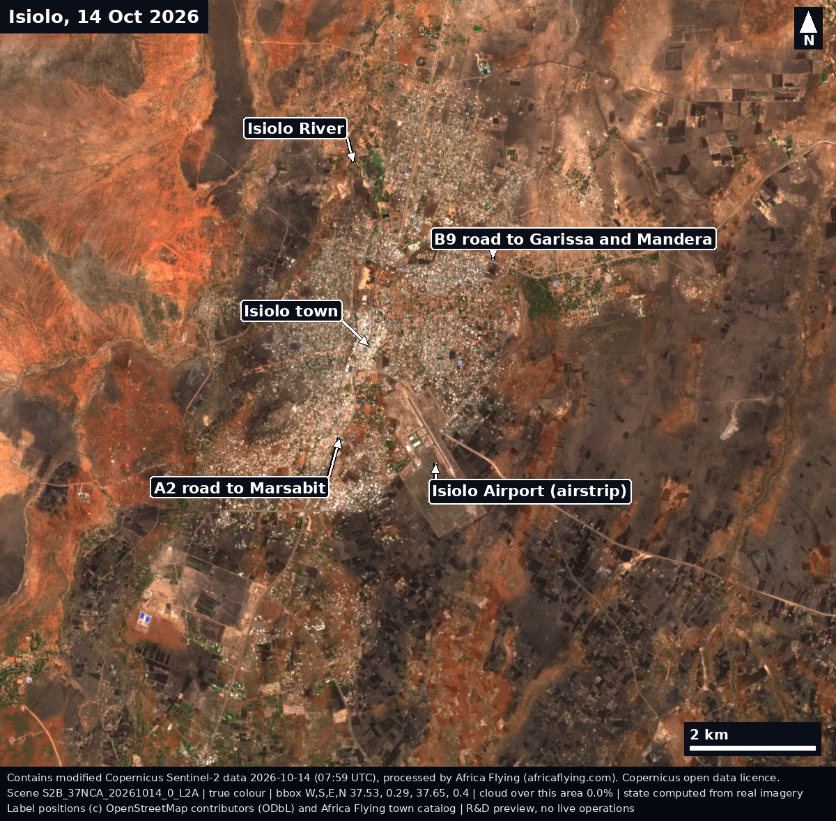
Sentinel-2 true-colour view of Isiolo, Kenya, on 14 October 2026, with labelled arrows to Isiolo town, the airstrip, the Isiolo River, the A2 road to Marsabit and the B9 road to Garissa.
Isiolo, 14 Oct 2026. Scene S2B_37NCA_20261014_0_L2A. Tap for full resolution.Credit: Copernicus Sentinel-2 L2A (2026-10-14), processed by Africa Flying. Labels (c) OpenStreetMap contributors, ODbL. Licence: Copernicus open data. Scene S2B_37NCA_20261014_0_L2A. Data date 2026-10-14. Cached at 19 Oct 2026 (saved image file). Provenance.
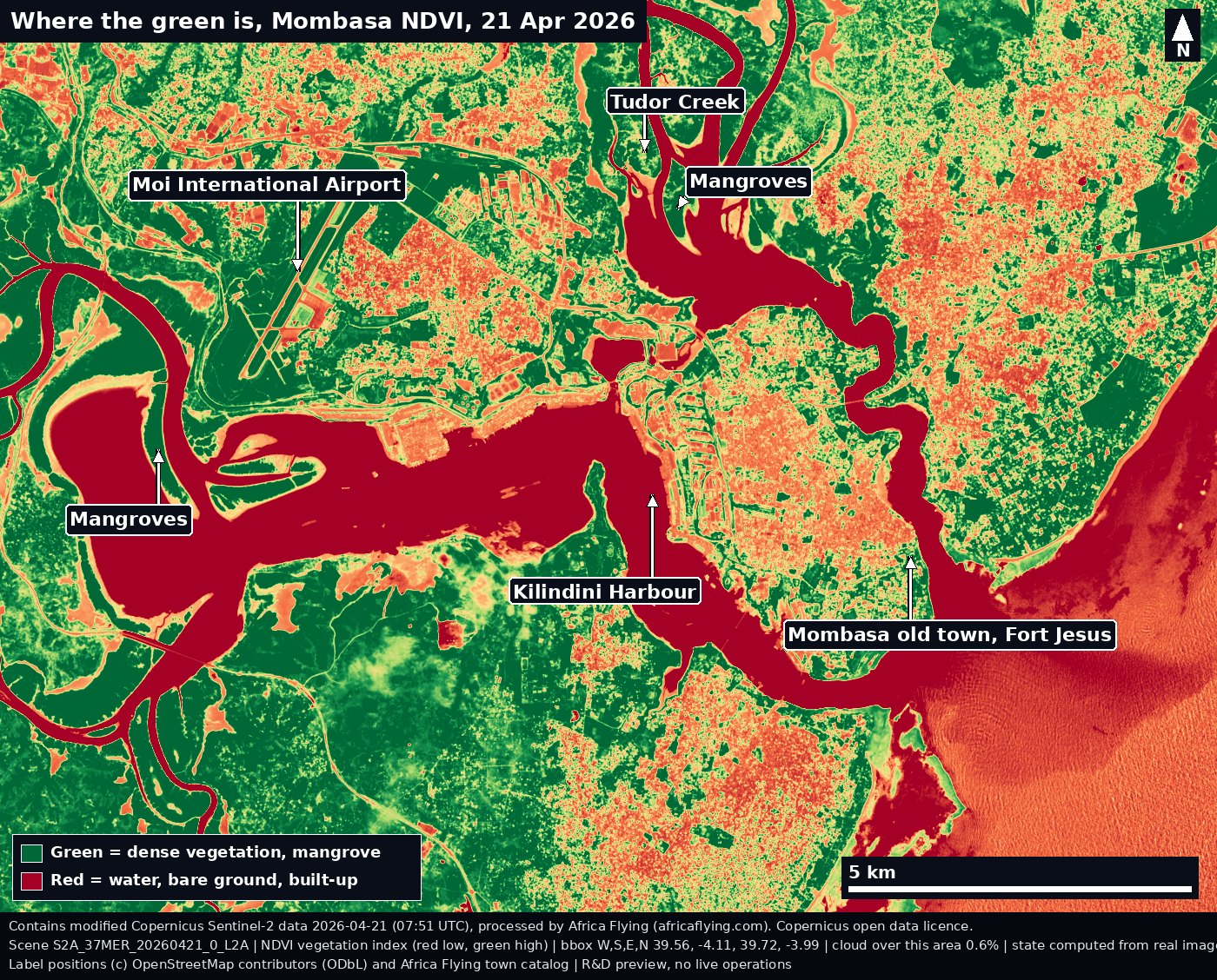
Sentinel-2 vegetation index (NDVI) map of Mombasa, Kenya, on 21 April 2026. Green shows dense vegetation and mangroves, red shows water, bare ground and built-up areas. Labelled arrows to two mangrove areas, Tudor Creek, Kilindini Harbour, the old town and Fort Jesus, and Moi International Airport.
Mombasa vegetation (NDVI), 21 Apr 2026. Scene S2A_37MER_20260421_0_L2A. Tap for full resolution.Credit: Copernicus Sentinel-2 L2A (2026-04-21), processed by Africa Flying. Labels (c) OpenStreetMap contributors, ODbL. Licence: Copernicus open data. Scene S2A_37MER_20260421_0_L2A. Data date 2026-04-21. Cached at 19 Oct 2026 (saved image file). Provenance.
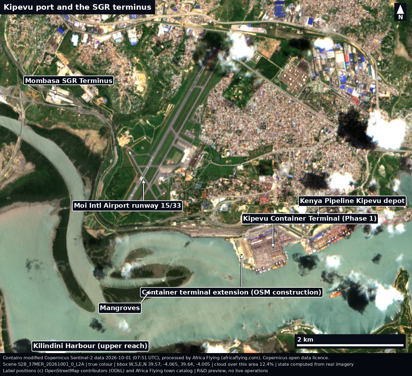
Sentinel-2 true-colour close view of Port Reitz and Kipevu, Mombasa, on 1 October 2026, with labelled arrows to the Kipevu container terminal and its extension, the Kenya Pipeline Kipevu depot, the SGR terminus, the airport runway, mangroves and the upper Kilindini Harbour.
Kipevu, Mombasa, 1 Oct 2026. Scene S2B_37MER_20261001_0_L2A. Tap for full resolution.Credit: Copernicus Sentinel-2 L2A (2026-10-01), processed by Africa Flying. Labels (c) OpenStreetMap contributors, ODbL. Licence: Copernicus open data. Scene S2B_37MER_20261001_0_L2A. Data date 2026-10-01. Cached at 19 Oct 2026 (saved image file). Provenance.

Fire

NASA FIRMS hotspots from the last seven days. Hotspots, not confirmed fires.
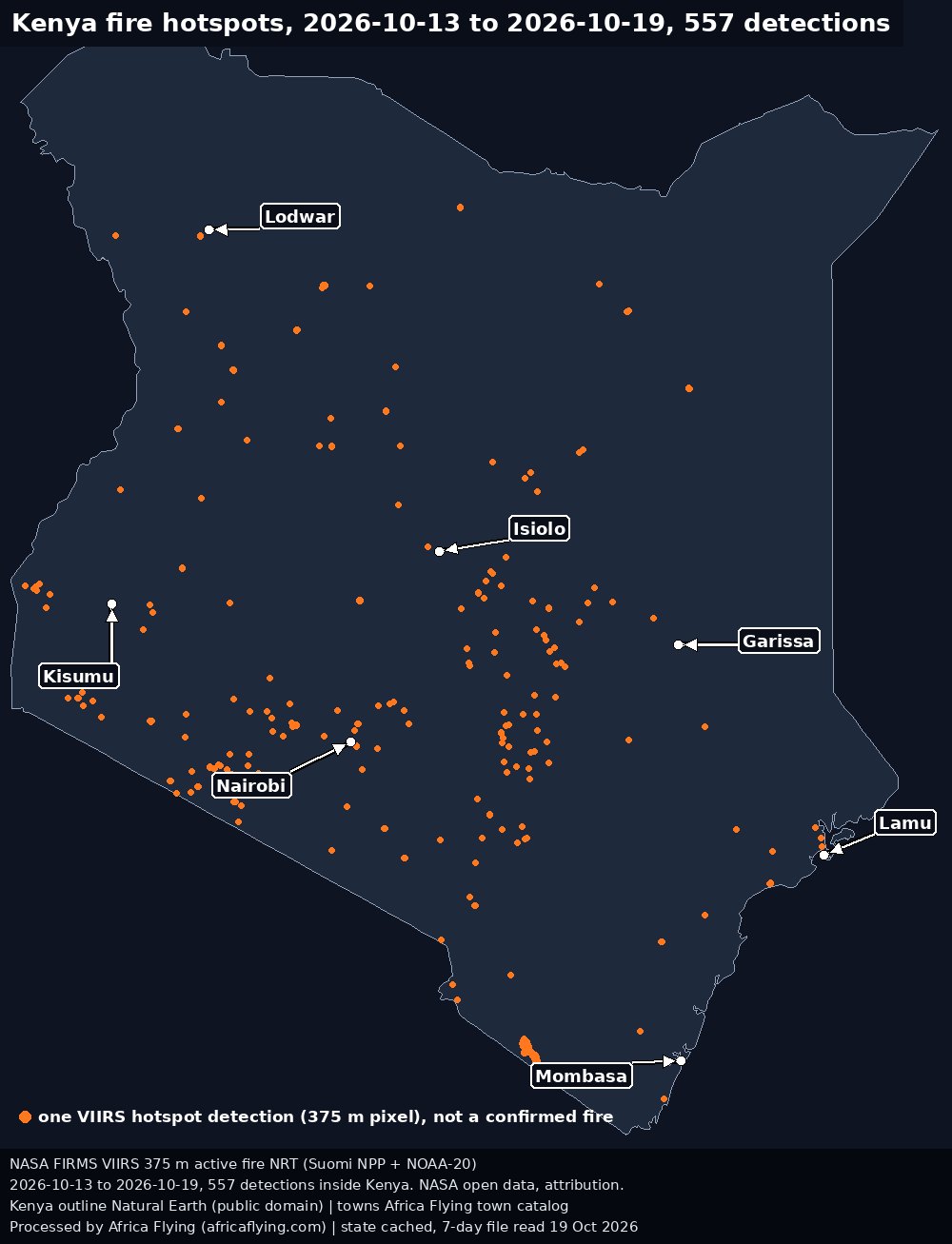
Map of Kenya with 557 orange dots, one per NASA FIRMS VIIRS satellite hotspot detection from 2026-10-13 to 2026-10-19, and labelled arrows to Nairobi, Mombasa, Lodwar, Isiolo, Garissa, Kisumu and Lamu.
Kenya, 2026-10-13 to 2026-10-19: 557 hotspot detections. Tap for full resolution.Credit: NASA FIRMS VIIRS 375 m NRT, Suomi NPP and NOAA-20 (NASA FIRMS, LANCE). Licence: NASA open data, attribution requested. Kenya outline Natural Earth, public domain. Town positions: Africa Flying town catalog. Data date 2026-10-13 to 2026-10-19. Cached at 19 Oct 2026 (7-day file read that day). Provenance.
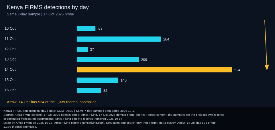
Bar chart of Kenya FIRMS hotspot detections by day in the 17 October 2026 sample, with an arrow to 14 October, the busiest day.
Detections per day in the 17 Oct sample. Credit: Africa Flying pipeline: 17 Oct 2026 domain probe, from NASA FIRMS rows. Licence: Project content; the numbers are the project's own records or computed from stated assumptions. Data date 17 Oct 2026. Cached at 17 Oct 2026 (saved chart). Provenance.

Then and now

The same place, one year apart, from Sentinel-2.
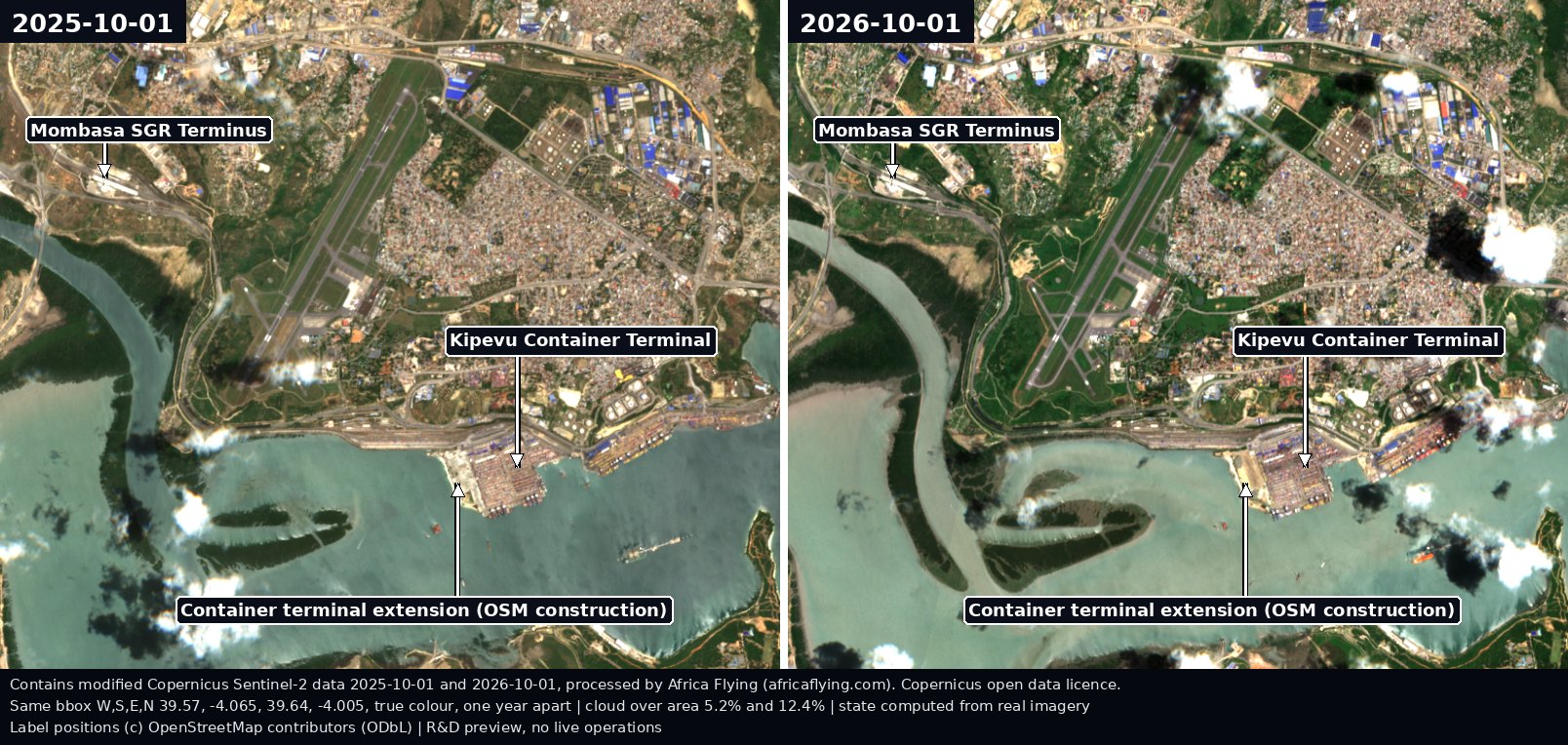
Two Sentinel-2 true-colour views of the same Kipevu and SGR terminus area of Mombasa side by side, 1 October 2025 on the left and 1 October 2026 on the right, with the SGR terminus, the Kipevu container terminal and the terminal extension labelled in both.
Kipevu, Mombasa: 1 Oct 2025 (left) and 1 Oct 2026 (right). Same box, same season. Tap for full resolution.Credit: Copernicus Sentinel-2 L2A (2025-10-01 and 2026-10-01), processed by Africa Flying. Labels (c) OpenStreetMap contributors, ODbL. Licence: Copernicus open data. Scene S2C_37MER_20251001_1_L2A. Scene S2B_37MER_20261001_0_L2A. Data date 2025-10-01 and 2026-10-01. Cached at 19 Oct 2026 (saved image file). Provenance.

How we know

Sources, licences and tools for every layer. Counts are pulled live from status, never typed in.

Source: Africa Flying public API (stored readings by type). Cached at data unavailable.